 Stratux
1What ADS-B is
ADS-B stands for Automatic Dependent Surveillance–Broadcast, and each word tells you something about how it works:
An ADS-B Out transmitter sends the aircraft's GPS position, altitude, ground speed and other data about once per second. Radar updates every 5 to 12 seconds. ADS-B ground stations are also far smaller than radar sites, so the FAA can put them where radar can't reach.
2ADS-B Out vs. ADS-B In
ADS-B Out is the transmitter. Since January 1, 2020, the FAA rule (14 CFR 91.225) has required it in most controlled airspace:
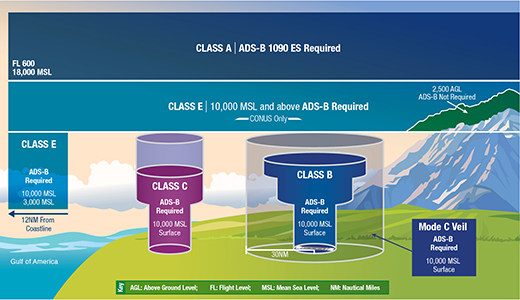
ADS-B In is the receiver, and it's optional. It's what puts traffic and weather on your display, either built into a panel or as a portable receiver that talks to your tablet. In the FAA's words, free traffic is available on all ADS-B In receivers, and free weather and flight information on receivers that can receive UAT.
3978 MHz vs. 1090 MHz: two links, two jobs
The US system runs on two frequencies, and they don't carry the same things:
- Airliners, jets and most turbine aircraft, plus many GA aircraft
- Required at and above FL180
- Works worldwide
- No FIS-B weather
- Many GA aircraft flying below 18,000 ft
- Allowed below 18,000 ft in the US
- US, and Canada via the CIFIB network
- The only link that carries FIS-B weather
A dual-band receiver hears both, so you get weather and direct air-to-air traffic from every ADS-B Out aircraft, without depending on the ground to relay it.
4FIS-B, TIS-B and ADS-R: what the ground sends
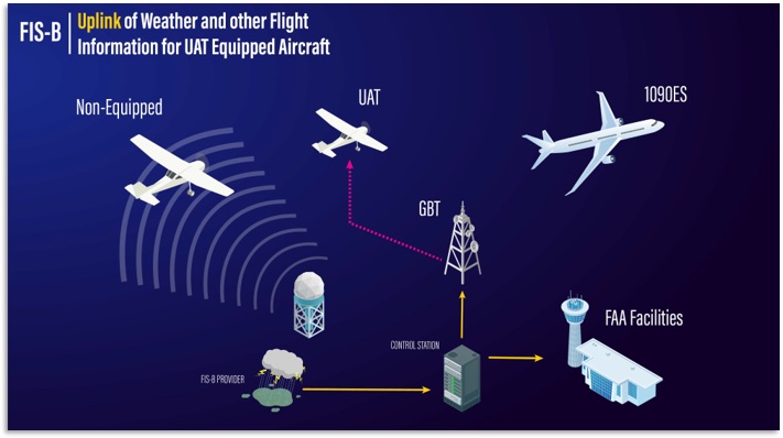
FIS-B Flight Information Service–Broadcast (weather)
Broadcast continuously on 978 MHz to anyone in range, with no transmitter required. It's not sent on 1090, so ADS-B weather needs a 978 MHz receiver.
TIS-B Traffic Information Service–Broadcast (radar traffic)
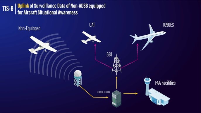
Many aircraft still don't have ADS-B Out. TIS-B fills that gap: ground stations take radar and multilateration targets (aircraft with a working transponder) and rebroadcast them on both frequencies. It's available at or below FL240, and only where there's both ground-station and radar coverage.
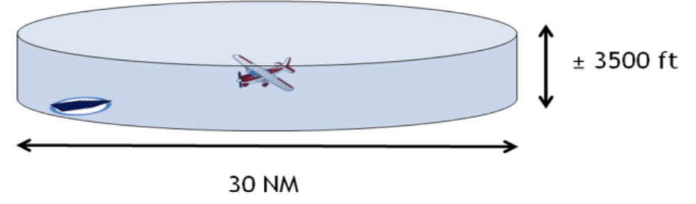
TIS-B is client-based. The ground station builds traffic for each ADS-B Out–equipped "client" aircraft, inside a cylinder around it 15 nm in radius and ±3,500 ft, nicknamed the hockey puck.
ADS-R Automatic Dependent Surveillance–Rebroadcast
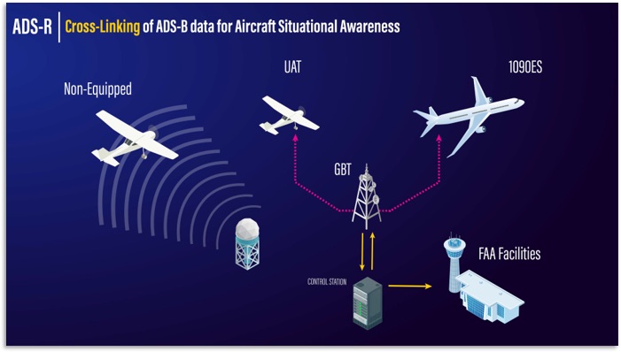
ADS-R bridges the two links. When a 1090 aircraft and a UAT aircraft are near each other, the ground station relays each one's broadcast on the other frequency so they can see each other. Like TIS-B, it's client-based and available at or below FL240.
5What a portable receiver sees without ADS-B Out
This part surprises most pilots. If your airplane has no ADS-B Out (or it doesn't meet the performance requirements), the ground stations don't know you're there, so they don't build a hockey puck around you. You only see ground-relayed traffic when you happen to be inside someone else's puck:
Without ADS-B Out you still get all FIS-B weather and direct air-to-air traffic from every aircraft with ADS-B Out on the frequencies you receive, which is the most reliable traffic you'll get. The FAA notes that piggybacked TIS-B and ADS-R give an incomplete picture, so treat a quiet display as "no traffic shown," never "no traffic." With your own qualifying ADS-B Out, a portable receiver gets the full picture built around you.
6Ground stations and range
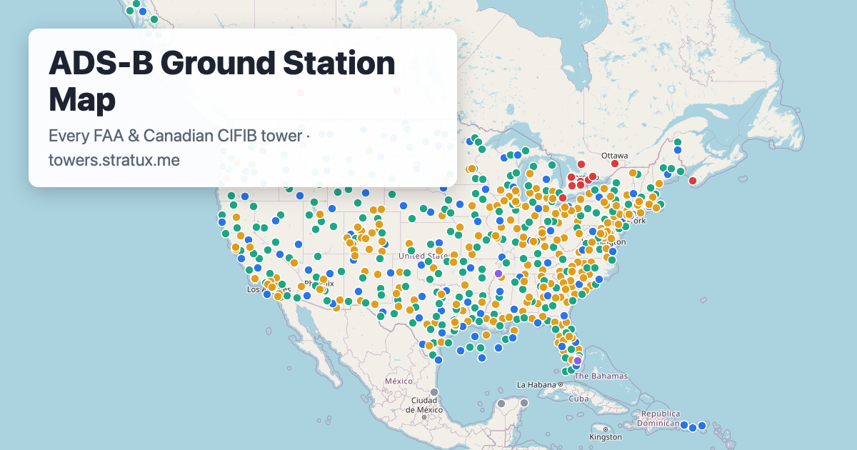
The FAA network has roughly 650 ground stations, all on our ADS-B ground station map. Each UAT station is assigned one of four altitude tiers (high, medium, low and surface), which sets the area it covers and the weather products it uplinks.
ADS-B is line of sight: terrain, buildings and the curve of the earth block it. That's why altitude matters so much. Drag the slider to see how far a receiver could hear a station in theory:
Radio-horizon estimate: d ≈ 1.23 × (√haircraft + √hantenna) nm, heights in feet, assuming a 100 ft station antenna and flat terrain. Real range is shorter: terrain, buildings, antenna placement and transmit power all cut it down. Not to scale vertically.
In the real world, receivers typically hear a station 40–60 nm away in the air but often under 1 nm on the ramp, where hangars, terrain and a low antenna block the signal. Most pilots start seeing weather around 1,000 ft AGL near a station, so no weather while you taxi is normal.
In Canada, the volunteer-run CIFIB network runs 978 MHz UAT stations in Ontario, Alberta, Saskatchewan and Nova Scotia. They broadcast the same way the FAA network does, so any US UAT receiver works with them. They're on the map in red.
7Using ADS-B safely
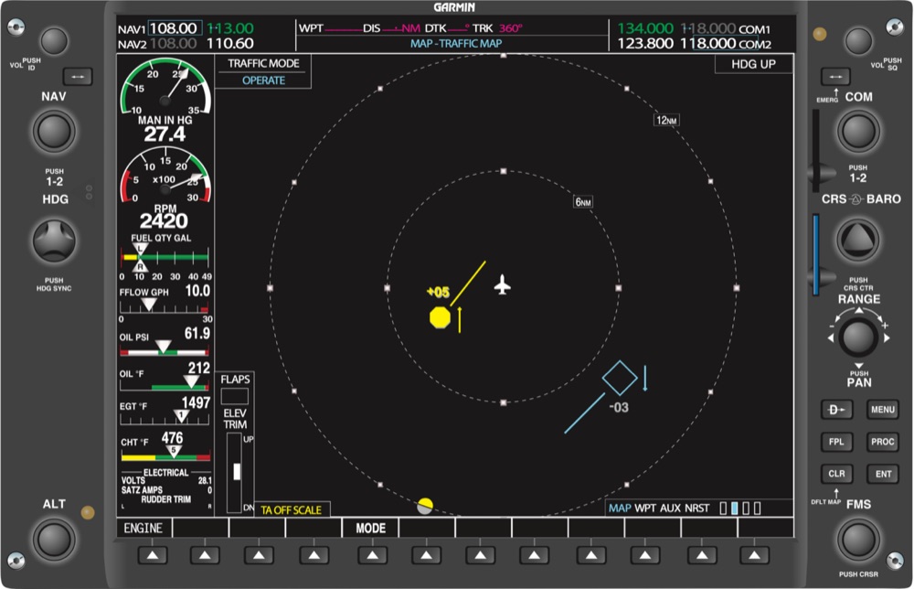

TIS-B isn't a collision avoidance system and doesn't replace see-and-avoid. Use it to spot traffic, not to maneuver around a target you can't see.
Aircraft without a transponder, or outside radar coverage, won't appear as TIS-B targets.
Uplinked radar can be several minutes older than it looks. Use it for strategic decisions, not to pick a path through a line of storms.
Many EFBs only show traffic within a band around you, commonly ±3,500 ft.
8What you need in the cockpit
You need two things: an ADS-B In receiver and a display, usually an EFB app on a tablet or phone. A portable receiver sits on the glareshield, creates a Wi-Fi network, and streams weather, traffic and GPS position to your EFB.
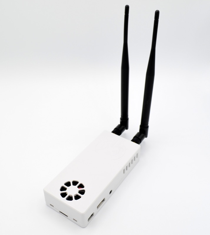
Stratux is an open-source, community-built ADS-B In receiver. It's dual-band (978 + 1090), so you get FIS-B weather and direct traffic on both links. It has GPS, and an optional AHRS gives you a backup attitude display (a valuable backup, not certified for IFR). It works with most popular EFB apps, including apps compatible with ForeFlight®, and because it's modular, every part can be repaired or replaced.
Frequently asked questions
Do I need ADS-B In?
No. The rule (14 CFR 91.225) requires ADS-B Out in most controlled airspace. ADS-B In is optional, but it gives you free weather and traffic in the cockpit.
Can a portable receiver show traffic if my airplane has no ADS-B Out?
Yes, partly. You'll see aircraft that broadcast ADS-B Out directly, plus TIS-B and ADS-R traffic generated for nearby aircraft that have it. That picture is incomplete; full service requires your own qualified ADS-B Out.
Why is there no ADS-B weather on the ground?
FIS-B comes from ground stations by line of sight, and on the ramp you're usually out of range. Weather typically appears after takeoff, often by about 1,000 ft AGL near a station.
Does ADS-B In work outside the United States?
1090 MHz traffic from other aircraft can be received worldwide. 978 MHz UAT and FIS-B weather are available in the United States and, through CIFIB, in parts of Canada.
Sources and image credits
- FAA, ADS-B Ins and Outs (FIS-B, TIS-B, ADS-R and hockey puck illustrations)
- FAA, ADS-B In Pilot Applications
- FAA, ADS-B Airspace (airspace illustration)
- FAA, Aeronautical Information Manual, Chapter 4, Section 5 (4-5-7 ADS-B Services, 4-5-8 TIS-B)
- FAA, Instrument Flying Handbook (FAA-H-8083-15B), figure 11-18, via Wikimedia Commons (public domain)
- CIFIB, Canadian In-Flight Information Broadcasting sites
- FAA images are works of the US government and in the public domain. Other illustrations and the Stratux photo are by the Stratux project. Coverage and on-the-ground range figures reflect Stratux community experience.